
VIIRS NASA Fire Product Validation
Version 1 Validation Statement
Both VNP14 and VNP14IMG Level 2 products are currently at stage 1 validation. Progress towards higher validation stages is dependent on future availability of quality reference fire data sets.
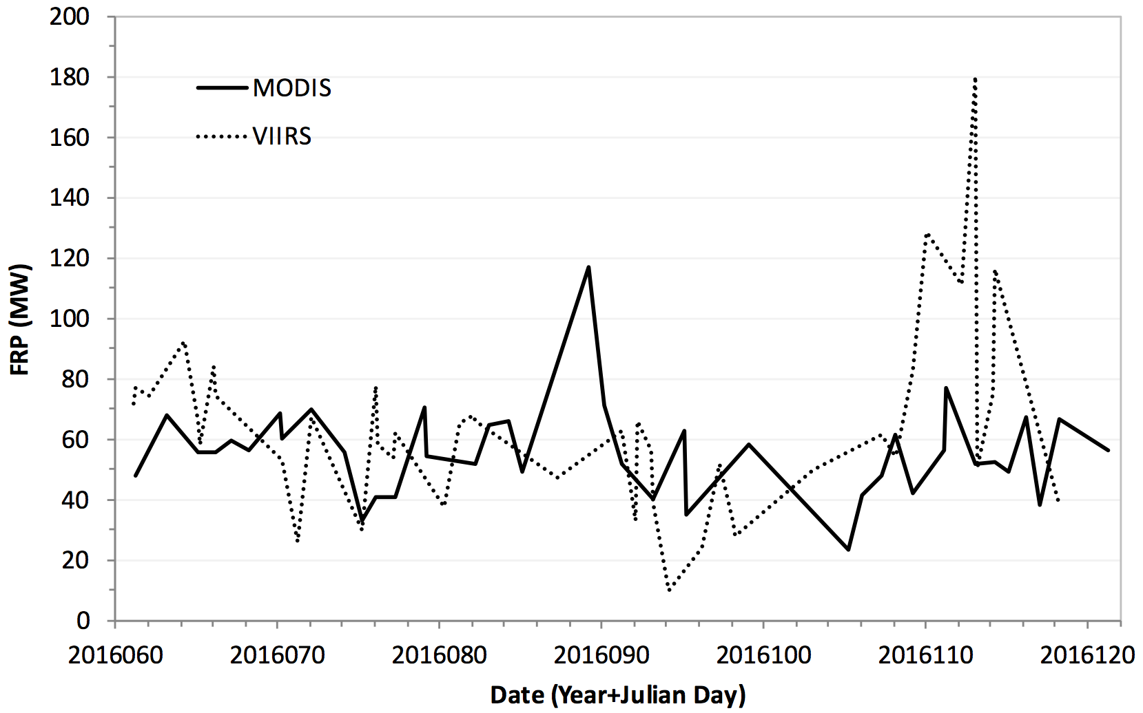
S-NPP/VIIRS hybrid 375/750 m (dashed line; Median=61.6MW) and Aqua MODIS
1 km Collection 6 (solid line; Median=55.5MW) fire radiative power (FRP) retrievals
produced over pseudo-static thermal anomaly (gas flare) in Iraq (30°45'50"N
47°19'38"E) for a 60-day period in 2016. Retrievals have been corrected for
atmospheric attenuation.
Quality assessment of the S-NPP/VIIRS active fire product suite has been approached using airborne and ground reference data acquired over select sites, complemented by evaluation of fire detection and characterization (fire radiative power [FRP]) data collected over pseudo-static sources often using near-coincident data from comparable spaceborne instruments. To date, the VNP14 and VNP14IMG Level 2 products have been satisfactorily validated during field campaigns in southeast United States (2012 Prescribed Fire Combustion and Atmospheric Dynamics Research [RxCADRE] in Florida), South Africa (2014 experimental fire campaign in Kruger National Park), and in Brazil (2017 experimental fire campaign in the states of São Paulo and Rio de Janeiro), in addition to several other fire data verification exercises encompassing ground-based and airborne survey of fire locations in the western United States (see graphic below) and Alaska, Thailand, Portugal, among others.
Gas-flares in the Middle East have been used as pseudo-static thermal anomalies for the evaluation of S-NPP/VIIRS FRP retrievals using near-coincident EOS-Aqua/MODIS 1 km (see graph at right) and the German Aerospace Center TET-1 small satellite 360 m data. Both sources indicate good overall agreement after accounting for sensor-specific considerations (e.g., atmospheric attenuation, bow tie effects). The VIIRS fire team also performed globally-representative assessment of VNP14 and VNP14IMG fire detection and FRP data using automated procedures selecting spatially- and temporally-coincident observations from EOS-Aqua/MODIS.
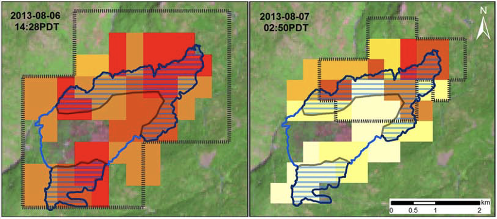
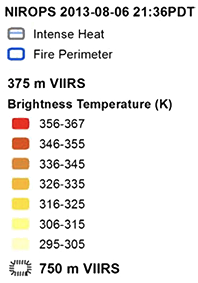
S-NPP/VIIRS 375 m (color-coded fire detection pixels) and 750 m (fire detection pixel outline) data acquired at 14:28 h PDT on 06 August 2013 and at 2:50 h PDT on 07 August 2013 over the Power Fire in California (38°15'00 'N 120°00'45"W). USDA-Forest Service NIROPS airborne data acquired at 21:36h PDT on 06 August 2013 shows the mapped fire perimeter as as well as the areas showing intense heat (Schroeder et al. 2014).
Fire data quality assessment results were consistent with the spatial resolution, and spectral and radiometric characteristics of S-NPP/VIIRS. We note, however, that the primary mid-infrared channel (M13) used for the FRP retrievals in both VNP14 and VNP14IMG products is subject to significantly stronger atmospheric attenuation compared to the corresponding MODIS mid-infrared channel. This effect is attributed to the CO2 absorption band partially overlapping the VIIRS M13 channel spectral response function. Results derived from radiative transfer models suggest +50% increase in atmospheric attenuation of M13 radiances compared to similar MODIS mid-infrared data.
Support Studies
Oliva, P., and Schroeder, W. (2016). Assessment of VIIRS 375 m active fire detection product for burned area mapping. Remote Sensing of Environment, 160, 144-155pp, doi:10.1016/j.rse.2015.01.010.
Dickinson, M.B., Hudak, A.T., Zajkowski, T., Loudermilk, E.L., Schroeder, W., Ellison, L., Kremensm, R., Holley, W., Martinez, O., Paxton, A., Bright, B.C., O'Brien, J.J., Hornsby, B., Ichoku, C., Faulring, J., Gerace, A., Peterson, D., and Mauceri, J. (2016). Measuring radiant emissions from entire prescribed fires with ground, airborne and satellite sensors - RxCADRE 2012. International Journal of Wildland Fire, 25, 48-61pp, doi:10.1071/WF15090.
Oliva, P., and Schroeder, W. (2015). Atmospheric correction of VIIRS and MODIS fire radiative power retrievals for multi-sensor comparison. IEEE Geoscience and Remote Sensing Symposium, doi: 10.1109/IGARSS.2015.7326200.
Csiszar, I., Schroeder, W., Giglio, L., Ellicott, E., Vadrevu, K.P., Justice, C.O., and Wind, B. (2014). Active fires from the Suomi NPP Visible Infrared Radiometer Suite: Product status and first evaluation results. Journal of Geophysical Research: Atmospheres, 119, doi: 10.1002/2013JD020453.
Schroeder, W., Oliva, P., Giglio, L., and Csiszar, I. (2014). The new VIIRS 375 m active fire detection data product: Algorithm description and initial assessment. Remote Sensing of Environment, 143, 85-96pp, doi:10.1016/j.rse.2013.12.008.