
VIIRS NASA LAI/Fpar Product Validation
Version 1 Validation Statement
Validation at stage 1 has been achieved for the VIIRS V1 LAI/FPAR product.
We have conducted two validation efforts (i.e., direct and indirect) to determine the VIIRS LAI/FPAR accuracy. The direct approach uses all available ground measured LAI/FPAR dataset (see plots a and b in the figure below) and the indirect approach compares VIIRS LAI/FPAR retrievals to those of MODIS (see plots c and d below). As the ground measurements obtained in VIIRS era are spatiotemporally limited, we consider the very mature and validated MODIS product to be an additional validation data source to be justified.
For the direct approach, when all ground LAI measurements are considered and the clumping effect is taken into account, the accuracy of LAI is 0.60 RMSE (Figure 1a). The accuracy of FPAR is 0.10 RMSE (Figure 1b). The indirect approach indicates highly consistent LAI/FPAR retrievals from both VIIRS and MODIS during first 5-years (2012-2016) of the VIIRS era. Estimated mean differences between VIIRS and MODIS are less than 0.05 for LAI and 0.01 for FPAR. This result provides confidence that the VIIRS product is comparable with MODIS (see MODIS LAI/Fpar Validation Status).
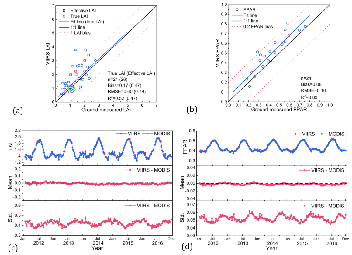
Figure 1. Comparison between VIIRS V1 and ground measured LAI/FPAR: (a) LAI and (b) FPAR. There are 21 LAI, 26 effective LAI and 24 FPAR measurements used here. The 3km × 3km sites, dominated by different biome types, are depicted by different colors. The circles and squares in upper left LAI panel represent ground LAI measurements corrected and not corrected, respectively, for clumping. Comparison between global VIIRS V1 and MODIS C6 LAI/FPAR during 2012-2016: (c) LAI and (d) FPAR. The 3 panels in lower graphs display seasonal and annual variation of VIIRS and MODIS (upper panel), seasonal and annual variation of mean difference (middle panel), and the standard deviation of the difference (lower) between VIIRS and MODIS.
Supporting Studies
Xu, B., Park, T., Yan, K., Chen, C., Zeng, Y., Song, W., Yin, G., Li, J., Liu, Q, Knyazikhin, Y., Myneni, R.B. 2018. Analysis of Global LAI/FPAR Products from VIIRS and MODIS Sensors for Spatio-Temporal Consistency and Uncertainty from 2012–2016, Forests, 2018, 9(2), 73. http://doi.org/10.3390/f9020073
Yan, K., Park, T., Chen, C., Xu, B., Song, W., Yang, B., Zeng, Y., Liu, Z., Yan, G., Knyazikhin, Y., Myneni, R.B. 2018. Generating Global Products of LAI and FPAR From SNPP-VIIRS Data: Theoretical Background and Implementation, Transactions on Geoscience and Remote Sensing, vol. 56, no. 4, pp. 2119-2137, http://doi.org/10.1109/TGRS.2017.2775247
Yan, K., Pu, T., Park, T., Xu, B., Zeng, Y.,Yan, G., Weiss, M., Knyazikhin, Y., Myneni, R.B. 2021. Performance stability of the MODIS and VIIRS LAI algorithms inferred from analysis of long time series of products, Remote Sensing of Environment, vol. 260, https://doi.org/10.1016/j.rse.2021.112438
Pu, J., Yan, K., Gao, S., Zhang, Y., Park, T., Sun, X., Weiss, M., Knyazikhin, Y., Myneni, R. B. 2023. Improving the MODIS LAI compositing using prior time-series information, Remote Sensing of Environment, vol. 287, https://doi.org/10.1016/j.rse.2023.113493
Román, M., Justice, C., Paynter, I., Boucher, P., Devadiga, S., Endsley, A., Erb, A., Friedl, M., Gao, H., Giglio, L., Gray, J., Hall, D., Hulley, G., Kimball, J., Knyazikhin, Y., Lyapustin, A., Myneni, R. B., Noojipady, P., Pu, J., Riggs, G., Sarkar, S., Schaaf, C., Shah, D., Tran, K., Vermote, E., Wang, D., Wang, Z., Wu, A., Ye, Y., Shen, Y., Zhang, S., Zhang, S., Zhang, X., Zhao, M., Davidson, C.,
Wolfe, R. 2024. Continuity between NASA MODIS Collection 6.1 and VIIRS Collection 2 land products, Remote Sensing of Environment, vol. 302, https://doi.org/10.1016/j.rse.2023.113963
Pu, J., Yan, K., Roy, S., Zhu, Z., Rautiainen, M., Knyazikhin, Y., Myneni, R. B. 2024. Sensor-independent LAI/FPAR CDR: reconstructing a global sensor-independent climate data record of MODIS and VIIRS LAI/FPAR from 2000 to 2022, Earth System Science Data, vol. 16, pp: 15-34, https://doi.org/10.5194/essd-16-15-2024