
VIIRS NASA Global Water Reservoir Product Validation
Version 1 Validation Statement
Validation at stage 1 has been achieved for the VIIRS Global Water Reservoir product (VNP28).
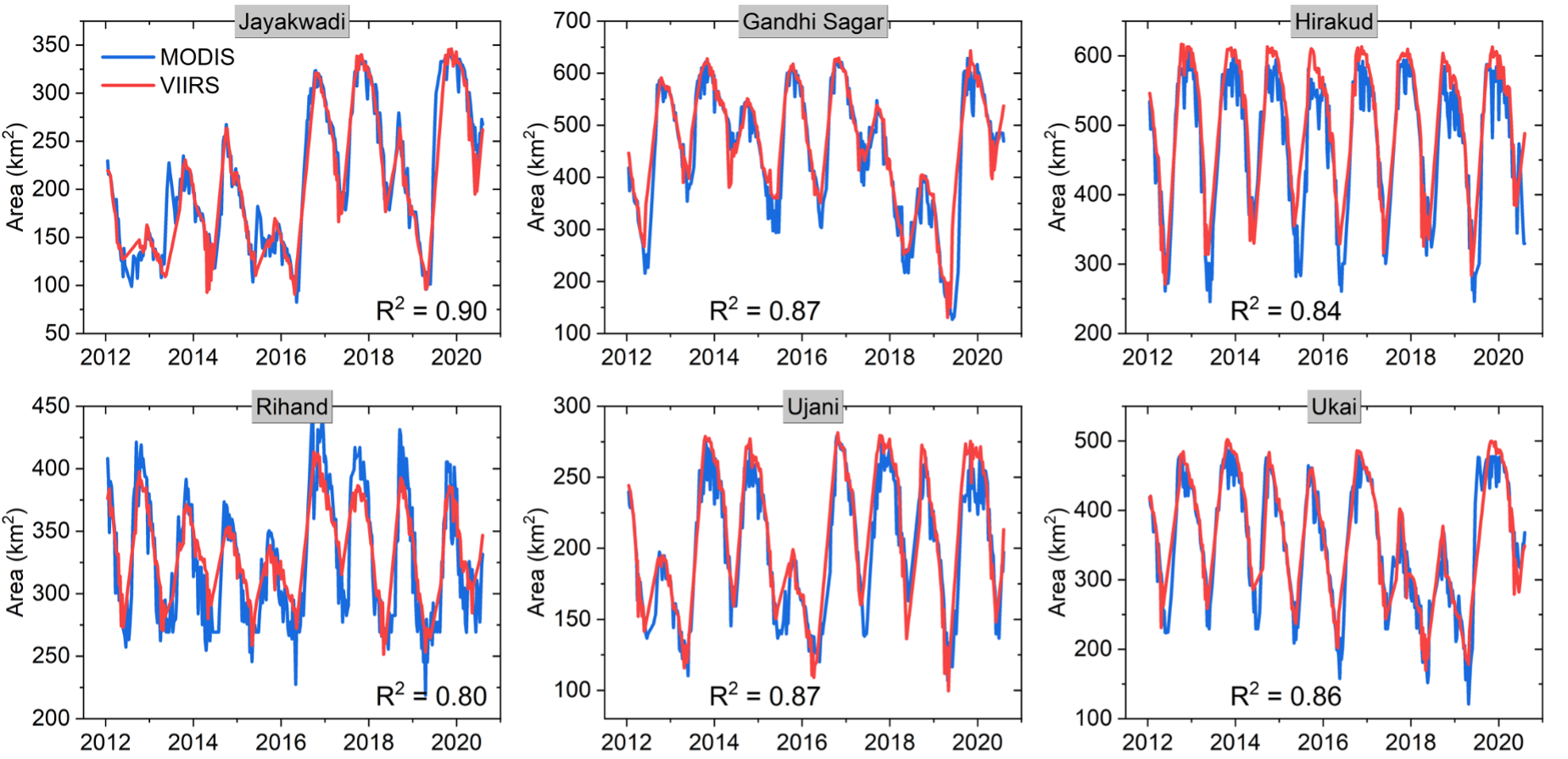
Figure 1. Comparison of 8-day area values between MODIS and VIIRS
from January 2012 to August 2020. Click on graphic to see larger version .
To evaluate the consistency of VIIRS and MODIS data, we selected six reservoirs from which to compare the 8-day area estimations from January 2012 to August 2020. As seen in Figure 1, the VIIRS based area values agree well with those of MODIS, with R2 value anging from 0.80 to 0.90.
The 8-day elevation and storage values also have good consistency, as they are based on the area estimations. In addition, high-quality monthly products can be generated from 8-day composite results (which are not shown here).
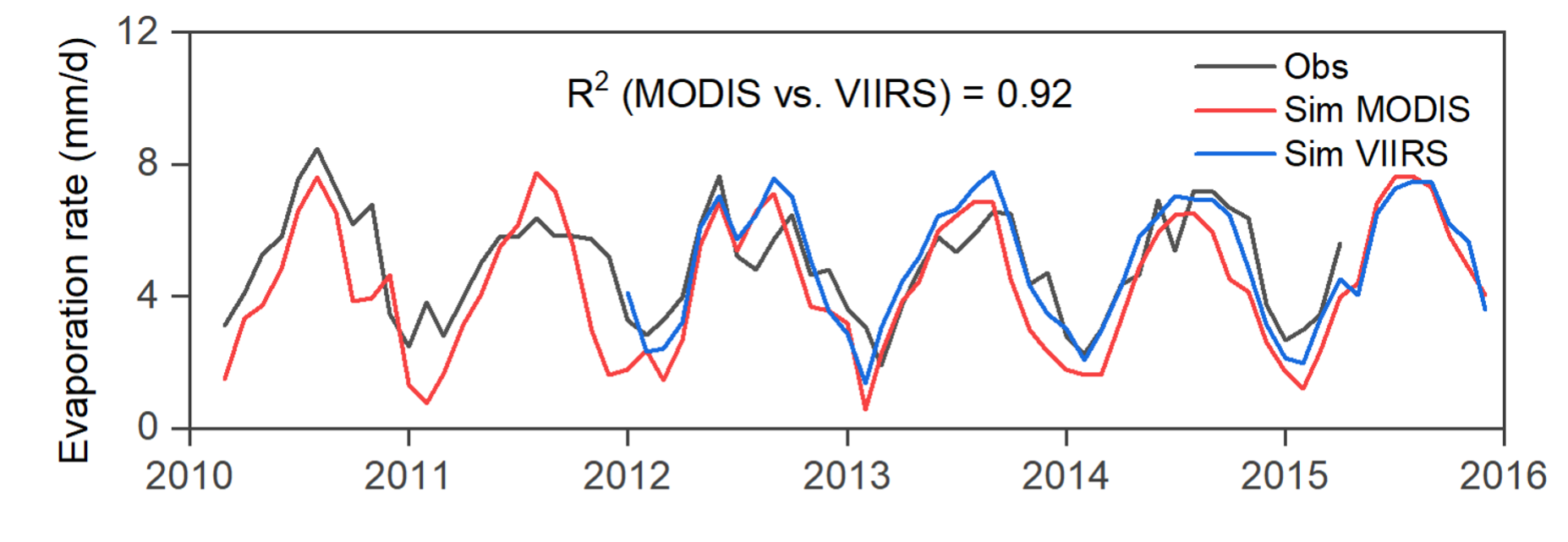
Figure 2. Comparison of monthly evaporation rates for Lake Mead
between MODIS and VIIRS. Click on graphic to see larger version
Additionally, we have selected Lake Mead to compare the evaporate rates from Jan 2012 to Apr 2015 (Figure 2). Validation results show that the evaporate rates of VNP28C3 have a higher accuracy than those of MOD28C3 in terms of R2 (0.76 vs. 0.66) and NRMSE (15.92% vs. 21.76%). Meanwhile, the evaporation rate results suggest a good consistency between VNP28C3 and MOD28C3 (R2 = 0.92).
Supporting Studies
Gao, H., Birkett, C., and Lettenmaier, D.P., 2012. Global monitoring of large reservoir storage from satellite remote sensing
Water Resources Research, 48
Zhang, S., Gao, H., and Naz, B.S. (2014). Monitoring reservoir storage in South Asia from multisatellite remote sensing.
Water Resources Research, 50, 8927-8943
Zhao, G., and Gao, H. (2018). Automatic correction of contaminated images for assessment of reservoir surface area dynamics.
Geophysical Research Letters, 45, 6092-6099
Li, Y., Gao, H., Jasinski, M.F., Zhang, S., and Stoll, J.D. (2019). Deriving High-Resolution Reservoir Bathymetry from ICESat-2
Prototype Photon-Counting Lidar and Landsat Imagery. IEEE Transactions on Geoscience and Remote Sensing, 57, 7883-7893
Zhao, G., and Gao, H. (2019). Estimating reservoir evaporation losses for the United States: Fusing remote sensing and
modeling approaches. Remote Sensing of Environment, 226, 109-124
Li, Y., Gao, H., Zhao, G., and Tseng, K.-H. (2020). A high-resolution bathymetry dataset for global reservoirs using
multi-source satellite imagery and altimetry. Remote Sensing of Environment, 244, 111831
Zhao, G., Gao, H., & Cai, X. (2020). Estimating lake temperature profile and evaporation losses by leveraging
MODIS LST data. Remote Sensing of Environment, 251, 112104
Li, Y., Zhao, G., Shah, D., Zhao, M., Sudipta, S., Devadiga, S., Zhao, B., Zhang, S., and Gao, H. (2021). NASA's
MODIS/VIIRS Global Water Reservoir Product suite from moderate resolution remote sensing data.
Remote Sensing, 13(4), 565; https://doi.org/10.3390/rs13040565.