
VIIRS Sea Ice Cover Product Validation
Version 1 Validation Statement
Validation at stage 1 has been achieved for the NASA VIIRS Sea Ice Cover (VNP29) product. A comparison was made between the VIIRS/NPP Sea Ice Cover 6-Min L2 Swath 375 m, Version 2 (Riggs et al., 2023) and the ice concentration from the AMSR-E/AMSR2 Unified L3 Daily 12.5 km Sea Ice Concentration product (Meier et al., 2018). Figure 1 shows the VNP29 swath on August 7, 2023 that is used for comparison.
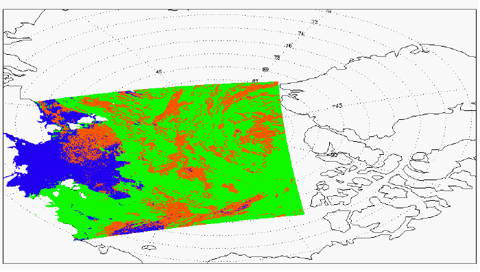
Figure 1. VNP29 VIIRS/NPP Sea Ice Cover 6-Min L2 Swath 375 m swath on August 7, 2023 that was inter-compared with AMSR ice concentration. Open water (blue), sea ice (orange) and cloud (green) is shown.
The standard definition of ice concentration > 15% is used to define the AMSR grid cell as “ice.” For all pixels where the VNP29 product shows ice (orange), the AMSR-2 concentration product has a 96.9% agreement. For open water (shown as blue), the agreement is 83.3%.
Support Studies
Meier, W. N., T. Markus, and J. C. Comiso. 2018. AMSR-E/AMSR2 Unified L3 Daily 12.5 km Brightness Temperatures,
Sea Ice Concentration, Motion & Snow Depth Polar Grids, Version 1. Boulder, Colorado USA. NASA National Snow and
Ice Data Center Distributed Active Archive Center. doi: https://doi.org/10.5067/RA1MIJOYPK3P.
Tschudi, M., G. Riggs, D. K. Hall, and M. O. Román. 2017. VIIRS/NPP Sea Ice Cover 6-Min L2 Swath 375 m, Version 1.
Boulder, Colorado USA. NASA National Snow and Ice Data Center Distributed Active Archive Center.
doi: https://doi.org/10.5067/VIIRS/VNP29.001.