
VIIRS NASA Land Surface Temperature and Emissivity Product Validation
Version 1 Validation Statement
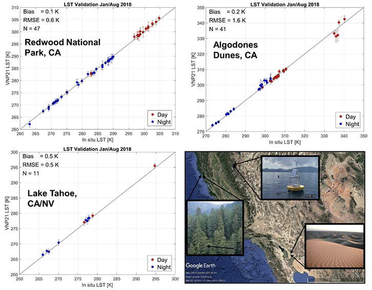
Example scatterplots of VNP21 Radiance-based LST validation at the Algodones dunes
and Redwood National Park sites and Temperature-based LST validation at Lake Tahoe
automated validation site. Corresponding emissivity validation between retrieved MOD21
emissivity, MOD11 classification emissivity, and lab spectra are shown in figure 2 below.
The VNP21 Land Surface Temperature and Emissivity (LST&E) product is at stage 1 validation status, defined as a product accuracy that has been assessed over a small (typically < 30) set of locations and time periods by comparison with in-situ or other suitable reference data.
The VNP21 LST&E product was validated to Stage 1 status using a combination of Temperature- and Radiance-based LST validation methods over select sites in the Southwest USA including two water sites (Lake Tahoe, Salton Sea), six land sites (Algodones, Kelso, Great Sands, Killpecker, Little Sahara, White Sands), and two vegetated sites (Redwood forest, Texas Grassland). These Stage 1 sites, although regional in scope, are largely representative of major global land cover types. Matchup data covered the period from 2012-2014. Stage 2 validation will be achieved once a global set of sites are used over a longer time period of data acquisitions.
Results for the Stage 1 validation of VNP21 LST data over the Southwest USA sites in Figure 1 showed stable and accurate LST retrievals to within 1.5 K RMSE with biases <0.5 K for both day and night data. The largest errors greater than 2 K occurred over Algodones dunes for view angles >65 degrees and contained pixels with high aerosol loadings from nearby fires. Average emissivity differences between retrieved VNP21 emissivity spectra and the lab measured spectra at Algodones dunes, CA in Figure 2 were within 0.015 (1.5% ) for all bands, and comparison with ASTER emissivity spectra were within 1% error for all bands (see Islam et al. 2017 for more details).
Details of VNP21 LST&E validation practices and methodologies can be found in the VNP21 ATBD and in Islam et al. 2017 supporting studies below, and conform to the CEOS LPV validation protocol for LST that can be found at the CEOS LPV web site.
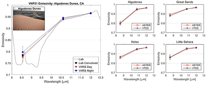
VNP21 day and night emissivity spectra versus lab measurements at Algodones, CA (left) and comparison with ASTER emissivity spectra (right).
Support Studies
Hulley, G. C., Malakar, N., Islam, T., Freepartner, R, (2017), NASA's MODIS and VIIRS Land Surface Temperature and Emissivity Products: A Consistent and High Quality Earth System Data Record, IEEE TGRS, DOI: 10.1109/JSTARS.2017.2779330.
Islam, T. G. C. Hulley, N. Malakar, R. Radocinski, S. Hook, P. Guillevic, (2017), A physics-based algorithm for the simultaneous retrieval of land surface temperature and emissivity from VIIRS thermal infrared data, IEEE Transactions on Geoscience and Remote Sensing, 55, 563-576