
NASA Evapotranspiration and Potential Evapotranspiration
User GuidePI - Maosheng Zhao (SSAI/NASA GSFC)
Product ATBDCo-Is: Arthur Endsley (University of Montana), John Kimball (University of Montana), Sadashiva Devadiga (NASA GSFC)
VIIRS VNP16 and VJ116, the global 8-day (VNP16A2/VJ116A2) and annual (VNP16A3/VJ116A3) terrestrial ecosystem Evapotranspiration (ET) and potential ET (PET) data products provide 0.5 km spatial resolution over the 109.72 million km2 global vegetated land areas. ET and PET are the combined term to describe the water loss through evaporation from land surfaces and transpiration from leaf stomata. Calculation of ET and PET is typically based on the conservation of either energy or mass, or both. Computing ET and PET requires the estimation and combination of two complicated estimations; the stomatal conductance of the vegetation to derive transpiration and evaporation from the ground surface.
The VIIRS ET and PET algorithm is based on the Penman–Monteith equation and it runs on a daily basis. Temporally, the daily ET is the sum of ET from daytime and nighttime; and vertically, ET is the sum of water vapor fluxes from soil evaporation, wet canopy evaporation and plant transpiration by dry canopy surface. Remote sensing has long been recognized as the most feasible means to provide spatiotemporally distributed regional ET information over land surfaces. Remotely sensed data, especially those from polar-orbiting satellites, provide temporally and spatially continuous information over vegetated surfaces useful for measurement and monitoring of surface biophysical variables affecting ET and PET, including albedo, biome type and leaf area index (LAI). The ET and PET algorithm combines these remotely sensed land surface biophysical information from VIIRS and sub-daily weather information obtained from a global meteorological reanalysis data set.
The issue of the cloud contaminated remotely sensed inputs from VIIRS 8-day FPAR/LAI and daily albedo to the ET and PET data products has been addressed. For the operational forward 8-day ET and PET, the 5-year rolling climatology 8-day FPAR/LAI and a previous year gap filled daily albedo are being used as backup to replace these contaminated values in the inputs to the algorithm. More importantly, in each early year, year-end gap filled 8-day and annual ET and PET will be created which use the year-end gap-filled VIIRS FPAR/LAI of the previous year as inputs to the algorithm to clean the cloud contaminated issue more thoroughly. We suggest users use gap filled VIIRS ET and PET (with “GF” in the HDF file names) for their studies if these studies don’t require the ET and PET data for the present year. This is because the present year only has forward data products (without “GF” in the HDF file names) and year-end gap filled data products are only for the previous years and can be created only when the full 8-day VIIRS FPAR/LAI for an entire year are available. In addition, for annual 16A3 ET and PET, there are only the gap-filled but not forward data products.
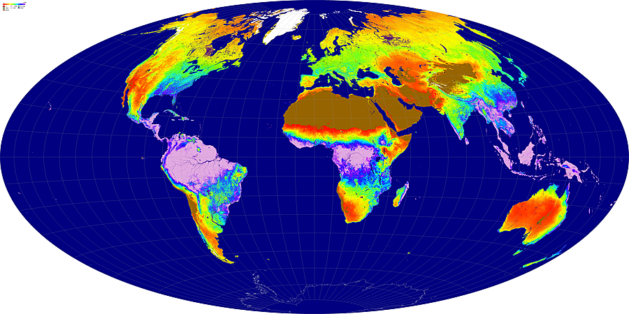
Global VIIRS EvapoTranspiration (ET, VNP16/VJ116) continues the global MODIS ET data product in a consistent way to provide 8-day and annual 500m ET for vegetated land.
The products are provided in standard Hierarchical Data Format–Earth Observing System (HDF-EOS5) format. Currently, this collection is available from January 19, 2012 and forward. Products from the VIIRS sensor aboard JPSS-1 (J1) will be also be available starting in mid-2023.
Product Details and DAAC links
| Product Name | SNPP | JPSS-1 |
|---|---|---|
| Evapotranspiration and Potential Evapotranspiration 8-Day L4 Global 1km | VNP16A2 | VJ116A2 |
| Evapotranspiration and Potential Evapotranspiration Gap-Filled 8-Day L4 Global 500m SIN Grid | VNP16A2GF | VJ116A2GF |
| Evapotranspiration and Potential Evapotranspiration Gap-Filled Yearly L4 Global 500m SIN Grid | VNP16A3GF | VJ116A3GF |