
NASA Land Surface Temperature & Emissivity Products
Product User GuidePI - Glynn Hulley (NASA JPL)
Product ATBDCo-Is: Simon Hook (NASA JPL)
Collaborators: Yunyue (Bob) Yu (NOAA), Pierre Guillevic (UMD/NASA GSFC)
A VIIRS Land Surface Temperature and Emissvity (LST&E) Product for Earth Science Research and MODIS Continuity
The VIIRS Land Surface Temperature and Emissivity (LST&E) algorithm and data products (VNP21) in Collection 1 (C1) are developed synergistically with the Moderate Resolution Imaging Spectroradiometer (MODIS) Collection 6 (C6) LST&E algorithm and data products (MXD21) using the same algorithmic approach and input atmospheric products. The overall objective for NASA VIIRS C1 products is to make the algorithms and products compatible with the C6 MODIS Terra and Aqua algorithms in order to ensure data product continuity and enable development of consistent, long term, and well characterized climate data records (CDR) from NASA's EOS satellites to the JPSS platforms. A long, stable record of LST is critical for monitoring climate trends, reducing systematic biases in land surface models, and is particularly useful for model evaluation in regions where few in situ measurements of surface air temperatures exist. Current differences between the NASA's MOD21 C6 and VNP21 C1 LST&E products originate only from the physical differences between the MODIS and VIIRS instruments such as spatial resolution, band locations, and instrument noise. Analysis has shown that these differences are at the <0.5 K level in retrieved LST for a wide range of land surface and atmospheric conditions (Islam et al. 2016).
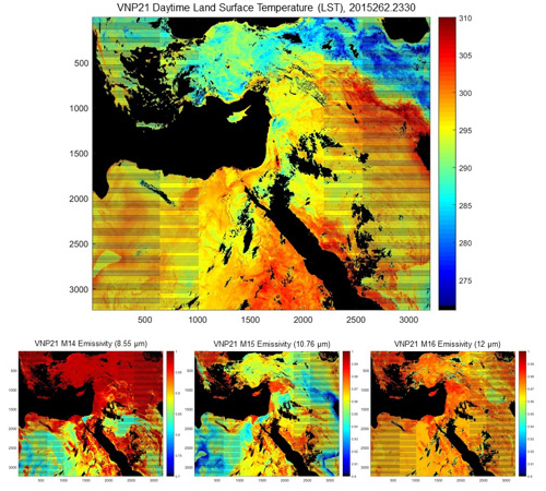
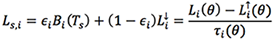
The NASA VNP21 LST&E product uses a physics-based Temperature Emissivity Separation (TES) algorithm to dynamically retrieve both the LST and emissivity simultaneously for the three VIIRS thermal infrared bands M14 (8.55 µm), M15 (10.76 µm), and M16 (12 µm) at a spatial resolution of 750m at nadir. The VNP21 algorithm derives its heritage from the MOD21 LST&E C6 product. TES uses full radiative transfer (RT) simulations to atmospherically correct the observed radiances, Li (θ) and estimate land leaving radiances.
Where atmospheric parameters, ![]() ,
, ![]() ,
, ![]() , are estimated with the RTTOV RT model using input atmospheric fields of air temperature, relative humidity, and geopotential height from NASA's MERRA-2 reanalysis product. Temperature (Ts)/emissivity (εi) are then separated using an emissivity model ("calibration curve") based on the variability in the surface spectral radiance data to dynamically retrieve both LST and spectral emissivity at native pixel resolution (see ATBD for details). Simulations and validation results have shown consistent accuracies at the 1 K level over all land surface types including vegetation, water, and deserts.
, are estimated with the RTTOV RT model using input atmospheric fields of air temperature, relative humidity, and geopotential height from NASA's MERRA-2 reanalysis product. Temperature (Ts)/emissivity (εi) are then separated using an emissivity model ("calibration curve") based on the variability in the surface spectral radiance data to dynamically retrieve both LST and spectral emissivity at native pixel resolution (see ATBD for details). Simulations and validation results have shown consistent accuracies at the 1 K level over all land surface types including vegetation, water, and deserts.
The VNP21 product will include a swath (scene) Level-2 daily product, and L3 daily and eight-day mean gridded products in sinusoidal projection (see product details below).
The products are provided in standard Hierarchical Data Format–Earth Observing System (HDF-EOS5) format. Currently, this collection is available from January 19, 2012 and forward. Products from the VIIRS sensor aboard JPSS-1 (J1) will be also be available starting in mid-2023.
Product Details and Links to LPDAAC
| Product Name | SNPP | JPSS-1 |
|---|---|---|
| Land Surface Temperature/Emissivity Twice-Daily 6-min L2 Swatd 750m | VNP21_L2 | VJ121_L2 |
| Land Surface Temperature/Emissivity Day L3 Global 1km | VNP21A1D | VJ121A1D |
| Land Surface Temperature/Emissivity Night L3 Global 1km | VNP21A1N | VJ121A1N |
| Land Surface Temperature/Emissivity 8-day L3 Global 1km | VNP21A2 | VJ121A2 |
| Land Surface Temperature/Emissivity Daily L3 Global 0.05 Deg CMG | VNP21C1 | VJ121C1 |
| Land Surface Temperature/Emissivity 8-Day L3 Global 0.05 Deg CMG | VNP21C2 | VJ121C2 |
| Land Surface Temperature/Emissivity Monthly L3 Global 0.05 Deg CMG | VNP21C3 | VJ121C3 |
References
Islam, T., Hulley, G.C., Malakar, N., Radocinksi, R., Guillevic, P.C., & Hook, S.J. (2016). A Physics-Based Algorithm for the Simultaneous Retrieval of Land Surface Temperature and Emissivity From VIIRS Thermal Infrared Data. IEEE TGRS, DOI: 10.1109/TGRS.2016.2611566
Malakar, N., & Hulley, G.C. (2016). A water vapor scaling model for improved land surface temperature and emissivity separation of MODIS thermal infrared data. Remote Sensing of Environment, 182, 252-264